D.C.-area forecast: Oppressively hot today and tomorrow, with triple ...
* Excessive-heat warning from 11 a.m. to 8 p.m. *
Today’s daily digit
A somewhat subjective rating of the day’s weather, on a scale of 0 to 10.
1/10: Hot as blazes. Thought about going 0, but I’m in a generous mood.
Express forecast
Forecast in detail
After hitting 101 on Sunday, we’re staring down what could be our hottest four-day stretch since at least 2016 and perhaps 2012. Highs on each of the next three days have a chance to reach the triple digits. Factoring in the humidity, it will feel 5 to 10 degrees hotter.
This is serious and potentially dangerous heat, especially for vulnerable groups such as the homeless, older adults and outdoor workers. Find ways to stay cool, hydrate and avoid strenuous exercise in the hottest parts of the day. Mercifully, the heat wave will end by Thursday.
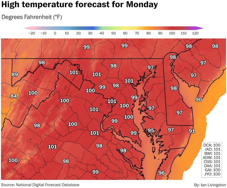
Today (Monday): If your walk to work involves more than a few minutes outside, you may need a shower by the time you arrive. The heat will be palpable early in the day and will get worse until peaking in the mid-to-late afternoon. Highs will be in the upper 90s and low 100s, challenging record highs of 100 at Reagan National, 98 at Dulles and 102 at BWI Marshall. Factoring in the humidity (dew points near 70), it will feel like 105 to 110. Like Sunday, a few gusty downpours could pop up, but most of us stay dry. Light winds from the west and southwest at 5 to 10 mph offer little relief. Confidence: Medium-High
Tonight: Partly cloudy and rather sultry. For areas near downtown, it will probably hold in the 90s until late in the evening with lows only settling near 80. In our cooler areas, lows will be closer to 75. Confidence: Medium-High
Follow us on Facebook, Twitter, and Instagram for the latest weather updates. Keep reading for the forecast through the weekend...
Tomorrow (Tuesday): It’s like today but the chance of a shower or storm is lower. Highs again reach the upper 90s and low 100s with peak heat indexes from 105 to 110. The record highs of 104 at the three airports (set in 1988) are a bit of a stretch but not out of the question. Confidence: Medium-High
Tomorrow night: It’s another uncomfortably muggy night with lows probably around 80 downtown and in the 70s elsewhere. There’s a small chance of a shower or thunderstorm late night as a front draws closer. Confidence: Medium-High
A look ahead
We’ll have one more chance to hit the century mark on Wednesday, with heat indexes up to 105 or so, but a cold front will sweep into the area. As it clashes with the steamy air, expect numerous showers and storms in the afternoon and evening, some of which will probably be intense. Showers and storms should decrease after sunset, with overnight lows in the 70s. Confidence: Medium-High
On Thursday, the cold front slips to our south but is close enough to keep a chance of showers and storms in the forecast, especially south and east of the District during the afternoon and evening. It’s not as hot with highs in the mid- to upper 80s. After any evening storms, it’s partly cloudy Thursday night, with lows from 70 to 75. Confidence: Medium
Friday is setting up to be the week’s nicest day, with partly sunny skies, moderate humidity and highs in the mid- to upper 80s. Partly cloudy at night with lows from 65 to 70 in our cooler areas and 70 to 75 downtown. Confidence: Medium
The front that stalled to our south on Thursday and Friday may try to lift north on Saturday, bringing clouds and a chance of showers and storms, especially south and east of Washington. As the front moves north of the area on Sunday, temperatures and humidity increase. Highs on Saturday are probably in the 80s before perhaps eclipsing 90 on Sunday. Lows should mostly be in the 70s. Confidence: Medium
Snow potential index
A daily assessment of the potential for at least 1 inch of snow in the next week, on a 0-10 scale.
0/10 (→): Muhahaha :)


