The power of Hurricane Kirk is continuing to bring great concern to several leading weather forecasters, just as Met Eireann issues its first weather alert.
Even before Kirk arrives, parts of the country that are already saturated could see more than 100 mm of rain this coming weekend with the south coast braced for the worst of it.
The heavy rain could last into next week and those in areas prone to flooding need to keep a close eye on the forecast, Alan O'Reilly of Carlow Weather has said.
In a tweet, he posted: "Latest update from models show a concerning level of rainfall Saturday with over 100mm possible in spots again. More possible on Monday too so need those in South in areas prone to flooding need to be alert."
Parts of Galway won't escape the heavy rain with up to 60mm possible in places.
Weather Alerts Ireland has also issued its own update for what's to come.
Sunday to Tuesday is looking like it's going to be very wet with heavy showers affecting the west and south coast. By Tuesday, the front will have moved east but left its mark.
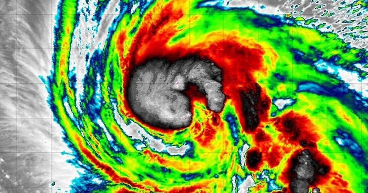
145mm of rain can be expected in parts of the south coast. By Thursday, Hurrican Kirk will likely move close to Ireland but its final path is still to be determined.
Weather Alerts Ireland posted: "Kirk has transitioned from a Tropical Storm into a Cat 1 Hurricane overnight! The path of Kirk still looks as though it will push towards Ireland but lots of uncertainty on this."
Meanwhile, Met Eireann has issued its latest forecast for the coming days. Today will be largely dry this morning with a good bit of sunshine. But by the afternoon, it will become cloudier with rain developing and becoming more widespread in the evening. Highest temperatures of 14 - 16 degrees.
TodayLargely dry this morning with some sunny spells. However, it will gradually become mostly cloudy with occasional rain and drizzle developing in the afternoon, becoming more frequent in the evening. Highest temperatures of 14 to 16 degrees with mostly moderate southeast winds, freshening in the west of the province later.
Solar UV IndexLow on Thursday and Friday.
TonightMostly cloudy tonight with outbreaks of rain and drizzle. Lowest temperatures of 8 to 13 degrees in moderate to fresh south to southeast winds.
TomorrowMostly cloudy and damp tomorrow with outbreaks of rain and drizzle. The best chance for any sunny spells will be in the afternoon. Highest temperatures of 14 to 17 degrees in moderate to fresh south or southeast winds. Mild and wet overnight with widespread rain, turning heavy in places with possible localised flooding. Temperatures won't fall below 11 to 15 degrees in moderate, occasionally fresh, south or southeast winds.
Join Galway Beo's top stories and breaking news service on WhatsApp. Click this link to receive breaking news and the latest headlines direct to your phone. We also treat our community members to special offers, promotions, and adverts from us and our partners. If you don’t like our community, you can check out any time you like. If you’re curious, you can read our Privacy Notice.


