Power cuts in Laois as lightning strikes causing Met Éireann to issue ...
Households and business have been suffering power cuts in Laois and neighbouring counties as thunder, lightning and heavy rain hits the Midlands.
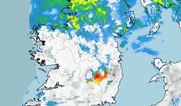
A Met Éireann weather map for Friday, July 14, shows several symbols around Laois, Kildare, Kilkenny and Carlow being hit by lightning.
Met Éireann explains that strikes, when they occur, are displayed with crosses on its maps. Initially, they are red but change to orange and then yellow after a period, then disappear.
As for the impact, the ESB reported that 2,487 customers were affected by faut around 6pm which has since being fixed. There are reports of cuts in other parts of the county.
Met Éireann issued a Status Yellow thunderstorm warning for Carlow, Kildare, Kilkenny, Laois and Wicklow at 6.22pm on Friday which warned of heavy thunderstorms locally with lightning.
The alert is valid until 10pm on Friday.
The thunderstorm warning follows a day of intense rain around Laois and the rest of the country which caused Met Éireann to issue a Status Yellow alert.
The national outlook from the forecaster shows no sign of a let up with heavy showers at times over the rest of the weekend with unsettled weather continuing into next week.
Met Éireann forecaster Liz Coleman explained what's behind the unseasonal conditions in a weather commentary. More below tweet.
— Met Éireann (@MetEireann) July 14, 2023“We've seen notable accumulations of rain over the south and southwest this morning (Friday). The band of persistent rain is now moving over the midlands and north of the country, bringing the possibility of localised flooding. Visibility is particularly poor in these conditions so do take care if you are travelling on the roads.
"It will be windy too for a time this afternoon, with fresh to strong easterly winds, leading to choppy conditions at sea particularly on eastern coasts. Isolated showers will follow into the south through the afternoon with some heavy and possibly thundery bursts and winds veering southwesterly. Yellow rainfall warnings are still in effect across the country," she said.
"Saturday we can expect a further band of rain or showers as the low pressure tracks eastwards, introducing fresh to strong and gusty north to northwest winds. It will be particularly windy along exposed coasts in the west and northwest, with gales likely at sea.
“We don’t want people to be caught off guard, especially with summer holidays in full swing. We ask people to keep up to date with the forecast for their area via www.met.ie and on the Met Éireann app. For further advice on how to plan accordingly check BeSummerReady,” she said.
Detailed forecast below tweet.
Dull☁️, wet️ & windy️ today & tomorrow with widespread & occasionally heavy outbreaks of rain.
Scattered heavy showers☔️ continuing on Sunday.
Quite blustery with fresh & gusty easterly winds, gradually veering westerly.
Afternoon temperatures️ in the mid to high teens. pic.twitter.com/Au57MOfs2I
National Forecast issued at 4.07pm on July 14.
Friday: Heavy persistent rain and blustery winds in northern parts for the rest of the day, bringing the possibility of localised flooding. Drier further south with some bright spells but also with a few heavy or thundery showers. Highest temperatures of 15 to 19 degrees, warmest in southern areas. The heavy persistent rain will become mostly confined to the northwest this evening.
Bands of rain will continue to move over northern counties and western counties overnight with clear spells and isolated showers elsewhere. Lowest temperatures of 10 to 13 degrees and winds will moderate overland.
Saturday: An increasingly windy day on Saturday with widespread showers or longer spells of rain. Moderate southwest winds in the morning will be replaced by fresh and gusty west to northwest winds for the afternoon and evening, which will be strong at times, especially near the coast. Highest temperatures of 15 to 18 degrees.
Wet and windy during Saturday night. Widespread showers across the country where some will be heavy and possibly thundery in the south. Breezy too with fresh to strong west to northwest winds and overnight lows of 9 to 12 degrees.
Sunday: Staying wet and rather windy as showers continue to feed in across the country. Some of the showers will be heavy and thundery during the afternoon and evening. Staying windy too with moderate to fresh westerlies and highest temperatures of 15 to 19 degrees.
The showers will gradually become isolated later in the evening with some clear and dry spells developing in the east. Westerly breezes will slowly weaken with lowest temperatures of 8 to 10 degrees.
Monday: A cloudy day with isolated showers to begin. Showers becoming more widespread as the day progresses with limited sunny spells. Highest temperatures of 15 to 18 degrees with light winds.
Showers will slowly clear later Monday evening with good clear and dry spells developing. Winds will fall light overnight too with lowest temperatures of 8 to 12 degrees. Rain will move over southern counties towards dawn together with strengthening easterly winds.
Tuesday: Wet and breezy across southern counties during the morning but elsewhere it will be a mix of cloud and isolated showers. Winds generally light across northern areas too with highs of 15 to 19 degrees.


