Storm Lilian: Weather warnings in place for UK as wind and rain hit
Storm Lilian hits sparking warnings of disruption
BBC News
A fallen tree blocking the road in South Road, Lancaster

Drivers and rail passengers are being warned of disruption as strong winds and heavy rain from Storm Lilian batter parts of the UK on Friday morning.
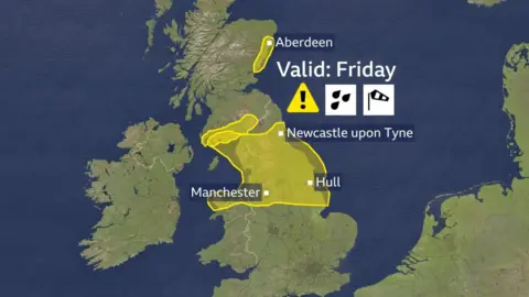
A Met Office yellow warning for winds in excess of 75mph has been issued across parts of northern England, southern Scotland and Wales until 11:00 BST on Friday.
Motorists have been advised of possible disruption on the M6 motorway, A66 and A1, while some train services have been delayed due to falling trees.
Creamfields Festival in Cheshire said there would be a delay to gates opening on Friday, while two stages have been closed at Leeds Festival due to strong winds.
Heavy rain spread eastwards overnight, with around 30mm recorded in North Wales.
The Met Office has issued a further yellow weather warning for heavy rain on Saturday from 06:00-13:00 BST for much of south east England, saying people should expect disruption and some flooding.
Meanwhile, two yellow weather warnings for rain were in place in parts of south-west and eastern Scotland overnight until 09:00 BST on Friday, with the potential for some localised flooding.

Lilian is the twelfth named storm of the season, the furthest through the list the Met Office has got since it was introduced in 2015.
Gusts of 50-60mph have been recorded widely and winds have already reached 72mph at Capel Curig in Wales.
Because trees are in full leaf, branches can fall more easily, which may lead to problems on the roads and rail networks.
There have also been warnings that flooding, power cuts and dangerous conditions near coastal areas are likely.
The Met Office said the storm should pass quite quickly, with the strongest winds forming initially across "parts of north Wales and into the Liverpool, Blackpool area".
The storm is then likely to move over the Pennines and into eastern and north-east England.
BBC Weather
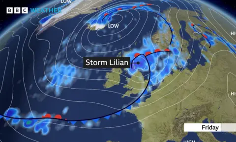
Storm Lilian will bring impacts to northern England and parts of Scotland with heavy rain and strongs winds on Friday
Leeds Festival said in an update on Friday that it could "see an end in sight" to the high winds but would not be opening its arena at 11:00 as planned.
However, there will be no performances on the BBC Radio 1 and Aux stages on Friday, it added.
Creamfields Festival warned there would be delays to public arenas and gates opening but it expected the winds to pass by mid-morning.
Tent takes flight at Leeds festival
A Network Rail spokeswoman said it is closely monitoring the "potential impact" the storm might have on the rail network.
"We have teams on hand to put in appropriate measures, if necessary, to ensure that we can continue to run trains safely and as reliably as possible," she added.
National Rail has reported travel disruption due to trees blocking the line in parts of Wales, the South-West, the West Midlands, while Northern said some lines across its network were blocked and passengers should expect delays or cancellations.
Some flights were cancelled at Heathrow on Friday morning due to strong winds, but the airport said it would be "operating as normal" and it was not worried about the weather.
The severe weather has already been felt outside the expected areas, with National Highways warning the M48 Severn Bridge in Gloucestershire has been closed in both directions between J1 (Aust) and J2 (Chepstow) due to strong winds.
Drivers have been advised to use the M4 Prince of Wales Bridge as an alternate route.
Merseyside Police also issued a warning to drivers on Friday morning.
Posting on X, the force said: "Its very windy out there due to #StormLilian so please take care if you are driving."
They also advised motorists to "slow down, avoid exposed stretches of motorway" and if possible, to delay travel.
Rain will reduce through the morning to leave a largely dry Friday with sunshine.
The strongest winds will transfer eastwards across north Wales and northern England throughout the morning and stay very blustery for most parts of the UK throughout the afternoon.
Winds are expected to calm over the bank holiday weekend, although wet weather is set to continue.
Why is it so windy in the UK?
BBC Weather
Storm Lilian is more typical of an autumn storm, not something we usually see in August (though we did have two named storms last August as well – Antoni and Betty).
Lilian is a deep area of low pressure that formed quite rapidly on Thursday night.
In meteorology, low pressure systems are the ones that give us the wet and windy weather.
The lower the pressure, the larger the pressure gradient is around its centre and it’s this that brings the stronger winds.
On a pressure chart, that is visualised by the white continuous lines. The closer they are, the windier it is.
These areas of low pressure have been directed to us by a fast wind high in the atmosphere flowing across the Atlantic. This wind – the jet stream – can either strengthen or weaken weather systems at the Earth’s surface.
Over the last few days, the jet stream has been particularly active, bringing the remnants of ex-hurricane Ernesto to our shores as well as creating Storm Lilian.


