The Status Orange Alert for Cork & Kerry - issued last night - comes into effect at midnight tonight and that means some very, very wet weather ahead, with the chance of thunder and river and coastal flooding.
This lunchtime, Met Eireann has updated its warning to include Waterford - the county can expect very heavy rain from midday to midnight tomorrow. Limerick and Clare are under Status Yellow warnings, which means the very worst of the weather will hit the southwest and south coasts.
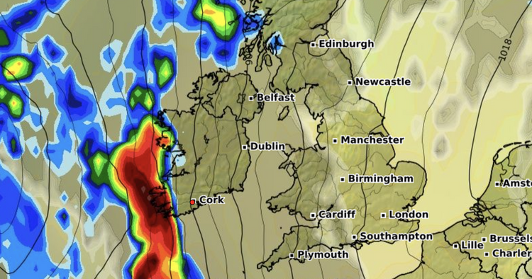
There is some slight relief for the South West this morning, with rainfall levels now expected to be slightly lower than what was predicted last night. But we could still see up to 100mm over high ground and 50-80mm on lower ground which translates into a major deluge with the change of spot flooding on roads.
Travelling conditions tomorrow will 'dangerous' according to Met Eireann and West Cork and Kerry look set to get the worst of it, with a very heavy band of rain hitting the coast from tomorrow (Saturday) morning and making its way west through the morning and afternoon.
The Status Orange, the second of the season so far, comes into effect at midnight tonight for 24 hours. Met Éireann are warning of "very heavy and persistent rain, with highest accumulations in mountainous areas of Kerry and west Cork."
Impacts:
River and coastal flooding Dangerous travelling conditions Travel disruptionThe full forecast this morning for Munster looks like:
TODAY - Friday 4th October
Today will be mostly cloudy and damp across Munster with scattered outbreaks of rain and drizzle. Highest temperatures of 15 to 17 degrees with moderate to fresh south to southeast winds.
TONIGHT
Tonight, rain will become persistent in the west. It will spread eastwards over the region overnight turning heavy at times with flooding likely, especially in the southwest. Lowest temperatures of 12 to 14 degrees with moderate to fresh south to southeast winds.
TOMORROW - Saturday 5th October
Saturday will be cloudy and wet with spells of rain in all areas. The rain be heavy at times with flooding likely. Highest temperatures of 13 to 15 degrees with fresh south to southeast winds.
National Outlook
Overview: Mild and generally unsettled with rain and showers.
Saturday night will continue wet with further spells of rain and some further flooding. The rain will become lighter and drier in the west and southwest overnight. Lowest temperatures of 9 to 12 degrees with southerly winds easing.
On Sunday, rain will gradually clear to the northeast. Sunny spells and showers will follow, some heavy, especially in Munster. Highest temperatures of 15 to 17 degrees with light to moderate southerly winds, fresher for the west and southwest. There will be further showers on Sunday night, heaviest in the south. Lowest temperatures of 7 to 11 degrees with light to moderate southeast breezes.
Monday will bring sunny spells and showers, heaviest and most frequent in Munster and south Leinster with localised flooding possible. Highest temperatures of 14 to 17 degrees in moderate southeasterly winds, fresher near coasts.
On Tuesday, there will be further showers, some heavy with a chance of isolated thunderstorms. Highest temperatures of 14 to 16 degrees with light to moderate mainly easterly breezes.
Further outlook: Overall it will continue unsettled with rain, showers and possibly strong winds at times.


