Potential storm headed for Ireland may hit England instead in ...
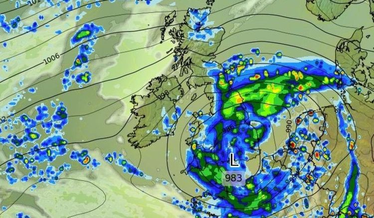
There is finally some good news on the weather front as a potential band of stormy weather that was seemingly heading toward Ireland is now going to hit England instead.
The update comes amid unsettled conditions nationwide with people left hoping for an upturn in weather fortunes before the Easter Bank Holiday weekend.
Alan O'Reilly from Carlow Weather gave the somewhat positive update: "In some potential good news for Bank Holiday Monday the latest charts show that low system heading for England rather than Ireland. Could change again yet but a positive update."
However, Met Éireann's forecast for the week and right into the Easter weekend is not good news with more rain and wind affecting much of the country.
Their outlook says: "Unsettled with frequent rain and showers, and the possibility of some flooding. Blustery at times also."
For Tuesday, they say "rain will continue over Connacht, Ulster, west Munster and north Leinster this afternoon. Turning brighter elsewhere with scattered heavy showers developing, bringing a chance of hail and isolated thunderstorms. Highest temperatures of 6 to 10 degrees in moderate northeast to east winds.
"Early tonight [Tuesday], rain will linger in Ulster, with a mix of clear spells and showers elsewhere. More persistent rain will develop in the south and southwest later, spreading northwards to most areas by morning. Lowest temperatures of 1 to 5 degrees in light to moderate easterly winds becoming southeasterly later."
The forecast continues: "Outbreaks of rain will gradually clear northwards on Wednesday morning and early afternoon. Sunny spells and showers will follow from the south for the rest of the day. Some showers will be heavy with the chance of hail and isolated thunderstorms, and with sleet possible on hills. Cool with highest temperatures of 5 to 9 degrees in moderate to fresh southeast to south winds.
"Wednesday night will be cold with showers mainly affecting Munster, Leinster and east Ulster, a few of them wintry on hills. Longer drier periods further west with clear spells. Lowest temperatures of -1 to 4 degrees, coldest over the western half of the country with frost and icy patches possible.
"Thursday will continue cold with bright or sunny spells and showers of rain or hail. These will be heaviest and most frequent in the east and north and a few may be thundery. Highest temperatures of 7 to 9 degrees with moderate northerly winds becoming westerly. On Thursday night, showers will become become isolated with clear spells and frost developing. Lowest temperatures of -1 to +2 degrees and light southerly or variable breezes."
For the Easter weekend, Met Éireann says "Good Friday will bring a mix of sunshine and showers. Some of the showers may be heavy with a continuing possibility of hail and thunder. Highest temperatures of 8 to 11 degrees with light to moderate southerly winds. Friday night will be another cold night with lowest temperatures of -2 to +4 degrees, coldest in the west.
"Easter Saturday will be somewhat milder with bright or sunny spells and some further showers, but not as many as previous days. Highest temperatures of 9 to 12 degrees with light breezes.
"Easter Sunday looks like being mainly dry with sunny spells and just a few showers. Highest temperatures of 10 to 12 degrees with light easterly breezes."
They conclude: "At the moment Easter Monday looks like being a wet day with rain spreading westwards over the country."
ADVERTISEMENT - CONTINUE READING BELOW
ADVERTISEMENT - CONTINUE READING BELOW
ADVERTISEMENT - CONTINUE READING BELOW
ADVERTISEMENT - CONTINUE READING BELOW
ADVERTISEMENT - CONTINUE READING BELOW
ADVERTISEMENT - CONTINUE READING BELOW
ADVERTISEMENT - CONTINUE READING BELOW
ADVERTISEMENT - CONTINUE READING BELOW
ADVERTISEMENT - CONTINUE READING BELOW


