Storm Debi: 14 counties under status red warning as schools in ...
A red wind warning has been issued for Kerry, Tipperary, Limerick, Clare, and 10 other counties as Met Éireann says extremely gusty winds on Sunday night brought by Storm Debi pose a "potential danger to life."
In an update on Sunday evening, Met Éireann says the storm could potentially cause damage to exposed and vulnerable structures, and disruption to services and transport. Significant power outages and fallen trees/branches are also likely, the forecaster said.
According to Met Éireann, when a status red warning is issued — which is rare — action must be taken to "protect yourself and your property."
The Department of Education is urging schools in counties affected by red and orange warnings to stay closed until 10 am on Monday at the earliest.
The National Emergency Co-ordination group met on Sunday evening and said the closure is to allow emergency services to clear debris off roads. It also said that it is up to school management if they should close for the full day.
Bus Éireann has advised that it will not be operating school transport on Monday morning in the counties affected by the Status Red and Orange warnings.
Afternoon services are intended to operate as normal, subject to local road conditions being safe to travel.
"Bus Éireann has advised it will not be operating school transport on Monday morning in the counties affected by the Status Red and Orange Warnings.
"Afternoon services are intended to operate as normal, subject to local road conditions being safe to travel," a Department of Education spokesperson said.
All Early Learning Care and School Age Childcare settings have also been requested by the Department of Children, Equality, Disability Integration and Youth to delay openings in red and orange affected counties until 10 am on Monday morning to "ensure public safety."
Weather warnings
The warnings come in the wake of devastation caused by flooding and intense rain during the preceding storms, Babet and Ciaran.
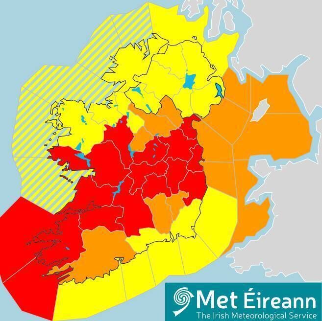
The status red warning is set to affect 14 counties. Picture Met ÉireannThe first alert for Clare, Kerry, Limerick, Tipperary, east Galway and south Roscommon will come into place at 2 am on Monday morning. It will stay in place until 5 am.
The second warning then will come into place at 5 am on Monday and will affect Dublin, Kildare, Laois, Louth, Meath, Wicklow, Offaly, and Westmeath.
It will stay in place until 8 am that day.
Furthermore, a status orange wind warning has also been issued for Cork as Met Éireann says Storm Debi can bring severe and damaging gusts.
The warning will come into effect at 1 am on Monday and stay in place until 4am that day.
From midnight on Sunday, the entire country will also be placed under a status yellow wind and rain warning.
Possible impacts of the adverse conditions may include localised flooding, hail, hazardous travelling conditions, and fallen trees and branches. The warning will remain in place until 3 pm on Monday afternoon.
Due to #StormDebi a wind warning is valid for Carlow, Dublin, Kildare, Kilkenny, Laois, Longford, Louth, Meath, Offaly, Westmeath, Wicklow, Clare, Kerry, Limerick, Tipperary, Galway
⏲️Valid: 02:00 - 12:00 Monday 13/11/2023
More about impacts here ????https://t.co/Xg3aMJlyuS pic.twitter.com/esopWypdm0
Then, from 2 am, a status orange wind warning will come into effect for counties Carlow, Dublin, Kildare, Kilkenny, Laois, Longford, Louth, Meath, Offaly, Westmeath, Wicklow, Clare, Kerry, Limerick, Tipperary, and Galway.
Until the warning lifts at midday tomorrow, Met Éireann is warning of:
Damage to exposed and vulnerable structures Disruption to services And damage to power linesMotorists in affected counties have also been warned of poor visibility and potentially dangerous travelling conditions.
Meanwhile, a red storm warning has also been issued from Mizen Head to Valentia to Slyne Head as Met Éireann says "westerly winds will reach violent storm force 11 for a time."
The alert will come into place at 2 am on Monday and stay in place until 5 am that day.
Lengthy delays in public transport expected says National Emergency Co-ordination group
Members of the public are being urged to stay away from all coastal areas for the duration of the Met Éireann warnings, according to the National Emergency Co-ordination Group.
Director-General for the National Directorate for Emergency and Fire Management (NDFEM), Keith Leonard said travel in counties where red warnings are present is "not advised."
"Motorists should slow down and be aware of the dangers of fallen trees and debris. High-sided vehicles, cyclists and motorcyclists are particularly vulnerable during this time," he said.
Lengthy travel delays in relation to public transport are also expected as well as disruption across all ports and airports.
"Employers are asked to be flexible to those who will be disrupted getting to work tomorrow and consider the option of working from home," Mr Leonard said.
Further advice includes:
Stay safe and stay clear of fallen or damaged electricity wires. Do not touch or approach fallen wires. Check transport websites for updates Check in on vulnerable neighbours Keep mobile charged.RSA warns road users to not travel during red warning in affected areas
The Road Safety Authority(RSA) is advising all road users to "take extreme care" over the next 24 hours as Storm Debi approaches.
The RSA is warning those in areas affected by the red warning to "not travel during the storm window."
"Road users are also advised to check local traffic and weather reports before setting out on a journey once the red warning has passed as storm damage could impact routes," a spokesperson said.
Those in areas affected by the orange warnings are being advised to check local traffic and weather conditions before setting out on a journey.
"In extreme weather conditions please heed the warnings of your local authority and Met Éireann. Don't make unnecessary journeys," the spokesperson added.
Speed restrictions for rail network due to Storm Debi
Iarnrod Eireann has announced speed restrictions for the entire rail network on Monday morning as a result of Storm Debi.
Significant delays are expected on all routes, they warned, saying a nationwide speed restriction of 50mph / 80kph will be in place.
“This safety precautionary measure is a result of the severe weather alerts issued by Met Éireann for Storm Debi,” a spokesperson said.
"They will also have crews out working on the lines to keep them clear but cautioned that fallen trees or other weather effects could cause additional disruption."
No Court services until 11:30 in counties impacted by red warning
Court buildings in the counties affected by any red weather warning will remain closed for the duration of the warning, the courts service said on Sunday evening.
Courts will not sit before 11:30am in the counties impacted by the red warning.
“Court users will be informed of these and any other updates via the courts.ie website and the Courts Service’s Twitter / X account,” a spokesman said.
Furthermore, in Cork, Cork county council has advised the public to stay away from coastal areas as warnings increase about Storm Debi.
The council’s Severe Weather Assessment group met on Sunday and warned of potential impacts linked to the Orange warning including damage to exposed and vulnerable structures, disruption to services and transport, significant power outages and fallen trees or branches.
In relation to the Yellow Wind and Rain warning, in effect until 3.00pm on Monday, they said possible impacts could include fallen trees/branches, localised flooding including wave overtopping and hazardous travelling conditions.
“Cork County Council wishes to advise road users to be aware of the danger posed by high winds,” they said.
“Driving conditions may be hazardous with surface flooding possible. Motorists are advised to drive with caution during heavy rain, not to drive through flood waters and be conscious of cyclists and pedestrians.” Dursey Cable Car will be closed on Monday and only return to operation when wind speeds permit and following inspection if necessary.
The public were advised to seek updates on the Cork County Council social media @Corkcoco.
Weather Outlook
Overall, Met Éireann is predicting thundery spells of rain across the county from this evening, particularly over Connacht and Ulster.
It said that "cyclonic variable winds" will also pick up in strength later tonight, resulting in stormy westerly winds and "severe" gusts.
Temperatures tonight will range from 6C to 10C.
As for Monday, the forecaster says the day will begin very windy or even stormy with further thundery rain in places, and some further severe or damaging gusts.
The rain will clear to the north as the morning progresses, giving way to sunny spells and heavy showers, before stronger to gale-force westerly winds eventually ease off by the afternoon.
The highest temperatures tomorrow will range from 9C to 13C.
Meanwhile, the UK Met Office has issued a yellow wind and rain warning for all of Northern Ireland on Monday.
It said heavy rain and strong winds due to Storm Debi may bring disruption and flooding to parts of the region.
It advised people to be aware that homes and businesses could be flooded and there could be disruption to bus, rail, and air travel.
The agency also warned possible fast-flowing or deep floodwater as well as possible flying debris could cause a danger to life. Power cuts are also possible.


